With over 60-70% of our citizens dependent on agriculture for their livelihood, India still is an agrarian economy, and an innovation in the Agriculture Sector can go a long way in boosting our output as a country.
The Agro Informatics Lab, IIT Bombay led by Professor Adinarayana works on one primary goal: finding innovative technological solutions which can be implemented in farms across India. Agro Informatics combines the modern concepts of Data Science, Information Technology and Machine learning with agriculture, to make farming more efficient and profitable.
It is difficult for farmers to gauge the health of their crops because they are unable to come up with objective measures to decide whether a crop is healthy or not. Crop health is a crucial factor in determining the output or yield of a crop. This poses a challenge to the agriculture industry, because farmers lack the information to decide which part of their field requires more resources and which requires less.
Agro Informatics Lab, IIT Bombay has come up with a solution to this problem. Using image processing, spectroscopy and machine learning, they have come up with a method to gauge the health of a plant objectively. Their solution provides farmers with valuable information such as which areas need to be irrigated more thoroughly and which areas need more fertilization. So, let’s have a look at how they do it.
Here’s the team:
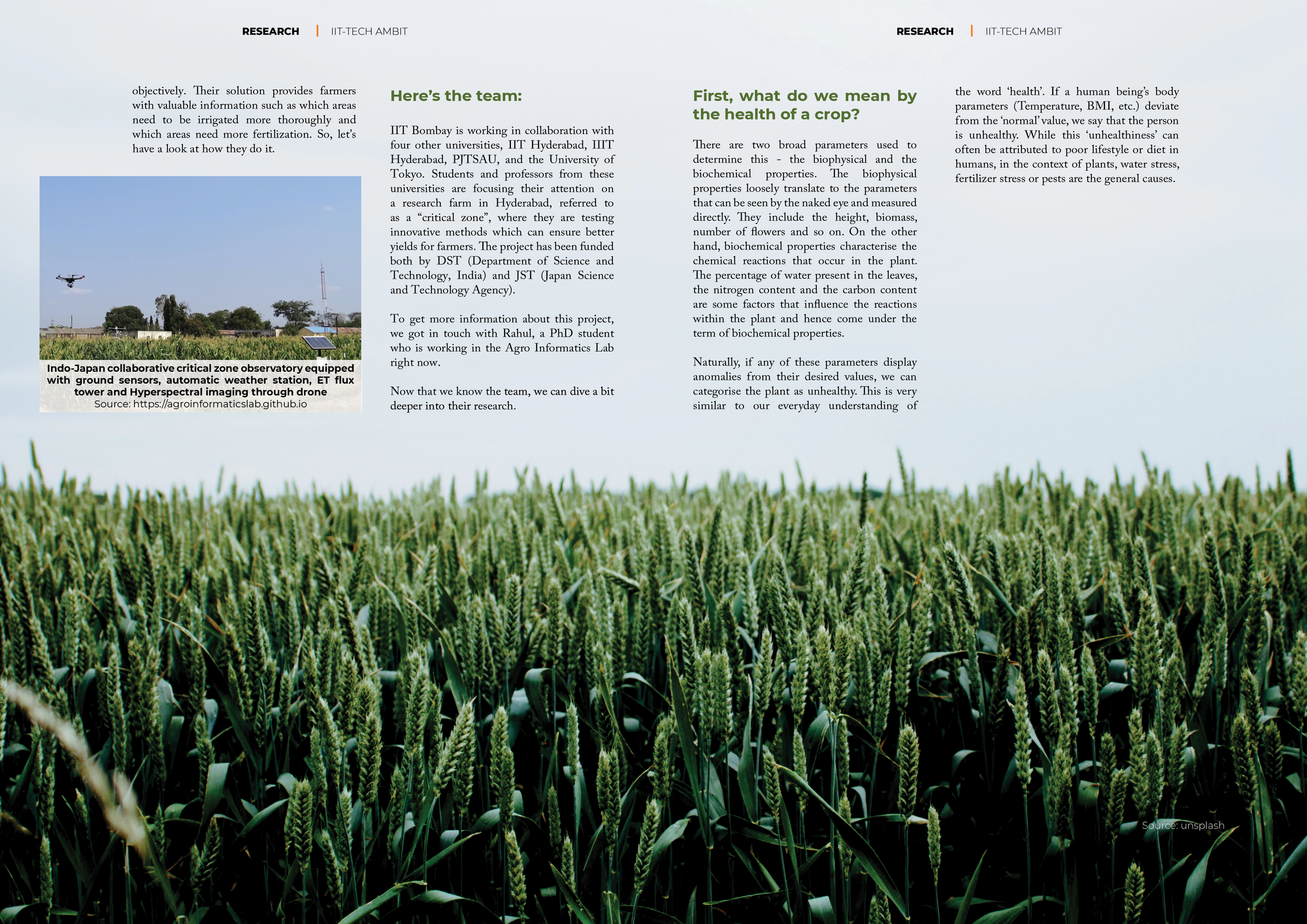
IIT Bombay is working in collaboration with four other universities, IIT Hyderabad, IIIT Hyderabad, PJTSAU, and the University of Tokyo. Students and professors from these universities are focusing their attention on a research farm in Hyderabad, referred to as a “critical zone”, where they are testing innovative methods which can ensure better yields for farmers. The project has been funded both by DST (Department of Science and Technology, India) and JST (Japan Science and Technology Agency).

To get more information about this project, we got in touch with Rahul, a PhD student who is working in the Agro Informatics Lab right now.
Now that we know the team, we can dive a bit deeper into their research.
First, what do we mean by the health of a crop?
There are two broad parameters used to determine this - the biophysical and the biochemical properties. The biophysical properties loosely translate to the parameters that can be seen by the naked eye and measured directly. They include the height, biomass, number of flowers and so on. On the other hand, biochemical properties characterise the chemical reactions that occur in the plant. The percentage of water present in the leaves, the nitrogen content and the carbon content are some factors that influence the reactions within the plant and hence come under the term of biochemical properties.
Naturally, if any of these parameters display anomalies from their desired values, we can categorise the plant as unhealthy. This is very similar to our everyday understanding of the word ‘health’. If a human being’s body parameters (Temperature, BMI, etc.) deviate from the ‘normal’ value, we say that the person is unhealthy. While this ‘unhealthiness’ can often be attributed to poor lifestyle or diet in humans, in the context of plants, water stress, fertilizer stress or pests are the general causes.
What is the solution?
Although the ultimate goal is to increase yield and produce healthy crops, the farmers often find themselves technologically handicapped to make such huge improvements. Moreover, several of them are skeptical about investing large sums of money for the cause as they are not fully aware of its benefits. In a data driven world, the team has smartly come up with a technique to harness the powers of drone based imaging to achieve healthy crops. This technique to achieve the objective of health monitoring relies heavily on data obtained through images of the farm scanned by drones. They make use of the Hexacopter DJI matrix 600, an automatic drone that can fly on a predefined path. These drones have several cameras attached to them, ranging from the daily used RGB cameras to fancy hyperspectral cameras. In fact, these hyperspectral cameras are what gives the team an edge over other people working in the field. These cameras have the capability of not only capturing wavelengths in the visible spectrum but also penetrating through the leaf and finding out what is happening within. The correct wavelength will be able to maximise the properties captured in a given photograph.

Satellite images are often used for health monitoring. These images, unfortunately, have low resolution (30m * 30m) and are generally filled with ‘noise’, or in simpler words, unwanted information. Contrary to this, the drones provide extremely rich images (1cm * 1cm). This helps us give a clear idea of the water and nitrogen content present in the plants. In technical terms, drone-based sensing gives pure pixels and this high-resolution mapping system makes it easy to identify the signs, i.e., the biophysical and the biochemical properties.
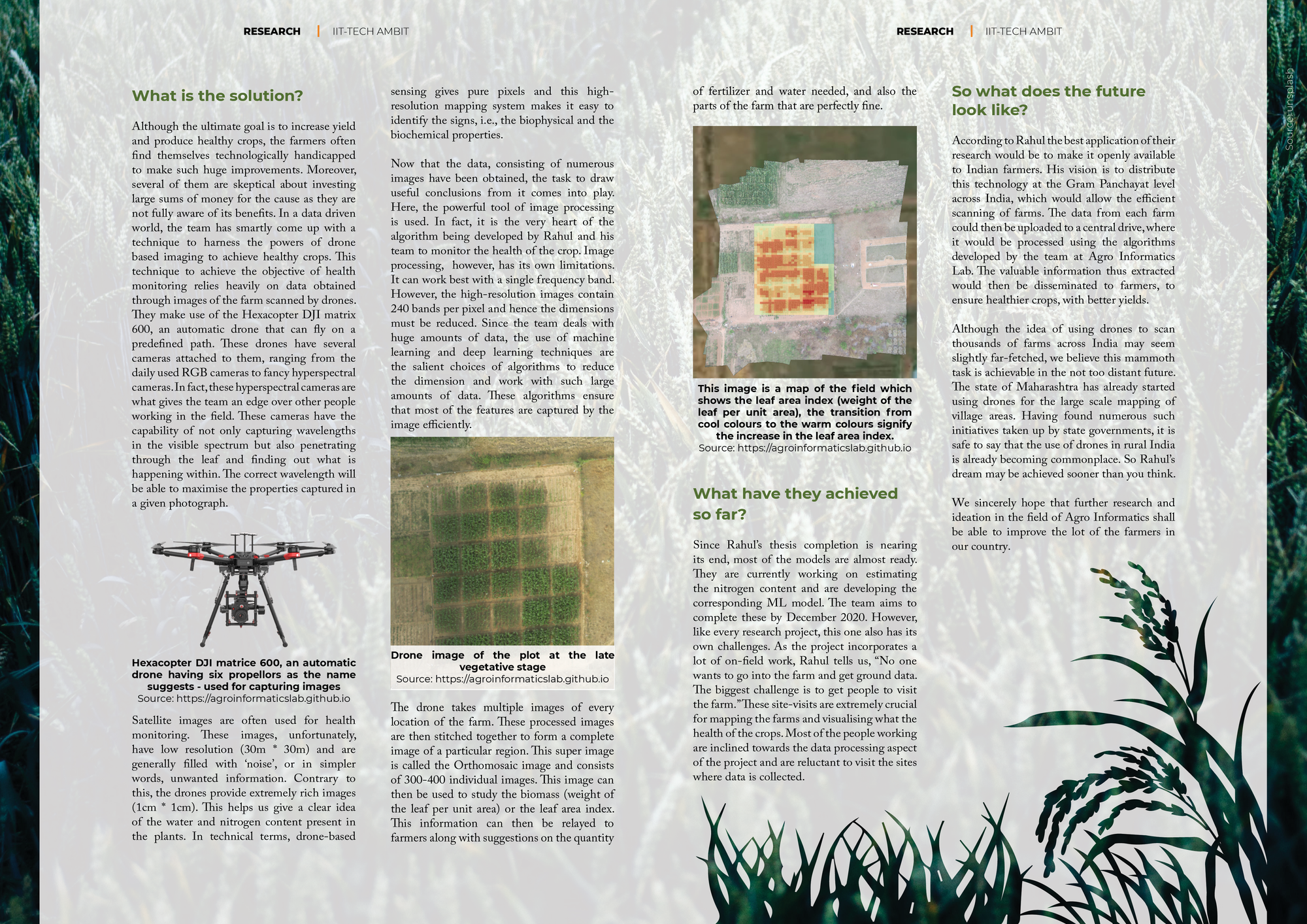
Now that the data, consisting of numerous images have been obtained, the task to draw useful conclusions from it comes into play. Here, the powerful tool of image processing is used. In fact, it is the very heart of the algorithm being developed by Rahul and his team to monitor the health of the crop. Image processing, however, has its own limitations. It can work best with a single frequency band. However, the high-resolution images contain 240 bands per pixel and hence the dimensions must be reduced. Since the team deals with huge amounts of data, the use of machine learning and deep learning techniques are the salient choices of algorithms to reduce the dimension and work with such large amounts of data. These algorithms ensure that most of the features are captured by the image efficiently.

The drone takes multiple images of every location of the farm. These processed images are then stitched together to form a complete image of a particular region. This super image is called the Orthomosaic image and consists of 300-400 individual images. This image can then be used to study the biomass (weight of the leaf per unit area) or the leaf area index. This information can then be relayed to farmers along with suggestions on the quantity of fertilizer and water needed, and also the parts of the farm that are perfectly fine.

What have they achieved so far?
Since Rahul’s thesis completion is nearing its end, most of the models are almost ready. They are currently working on estimating the nitrogen content and are developing the corresponding ML model. The team aims to complete these by December 2020. However, like every research project, this one also has its own challenges. As the project incorporates a lot of on-field work, Rahul tells us, “No one wants to go into the farm and get ground data. The biggest challenge is to get people to visit the farm.” These site-visits are extremely crucial for mapping the farms and visualising what the health of the crops. Most of the people working are inclined towards the data processing aspect of the project and are reluctant to visit the sites where data is collected.
So what does the future look like?
According to Rahul the best application of their research would be to make it openly available to Indian farmers. His vision is to distribute this technology at the Gram Panchayat level across India, which would allow the efficient scanning of farms. The data from each farm could then be uploaded to a central drive, where it would be processed using the algorithms developed by the team at Agro Informatics Lab. The valuable information thus extracted would then be disseminated to farmers, to ensure healthier crops, with better yields.
Although the idea of using drones to scan thousands of farms across India may seem slightly far-fetched, we believe this mammoth task is achievable in the not too distant future. The state of Maharashtra has already started using drones for the large scale mapping of village areas. Having found numerous such initiatives taken up by state governments, it is safe to say that the use of drones in rural India is already becoming commonplace. So Rahul’s dream may be achieved sooner than you think.
We sincerely hope that further research and ideation in the field of Agro Informatics shall be able to improve the lot of the farmers in our country.