Dr. Albert Sunny received his PhD and MSc degrees in Engineering from IISc (Indian Institute of Science), Bangalore. He is currently an Assistant Professor at IIT Palakkad’s Department of Computer Science and Engineering. Prior to this, he was a post-doctoral researcher at INRIA, France. His research interests and publications are largely focused on the analysis and modelling of wireless, social and transportation networks.
Dr. Sudheesh T. K. did his PhD in Civil Engineering from University of Florida, USA. He has done an extensive amount of work in areas such as Geotechnical Engineering, Foundations, Slope Stabilization and Soil Structure Interactions. At present, he is an Assistant Professor at the Civil Engineering Department here at IIT Palakkad.
LANDSLIDES:
A landslide (also known as a landslip) refers to the movement of a large amount of rock, earth, or debris, down a sloped section of land. Landslides are mostly caused by rain, earthquakes, and less noticeable factors such as soil erosion. They are a frequent occurrence in hilly regions that experience heavy rainfall, such as northeast India.
Human activities such as construction and mining are also known to exacerbate the risk of landslides. Landslides can be devastating – often claiming lives and damaging infrastructure. Landslides can also increase the risk of flooding when they occur near rivers and other water bodies.
Being able to predict the chances of a landslide occurring in a particular area (ahead of time) is a valuable ability that could potentially save lives and mitigate damage. Hence, the need for a real-time monitoring system that can predict slope failure that is in the works at IIT Palakkad. Piloted by Dr. Albert Sunny and Dr. Sudheesh, this project not only aims to be robust, but also cost-effective, energy-efficient and easy to deploy.
A ZIGBEE NETWORK SOLUTION:
The team plans on achieving the objective of predicting landslides with the help of a solar powered Zigbee-based wireless sensor network. Zigbee is a wireless technology developed as an open global standard to address the unique needs of low-cost, low-power wireless IoT (Internet of Things) networks.
The idea is to place wireless sensors in areas which are prone to landslides, so that physical quantities of interest such as pore water pressure (pressure of groundwater held in the soil), rainfall and soil movement can be monitored. These parameters are known to significantly impact the chances of a landslide occurring. Hence, these observations can be used to compute the probability of slope failure with the help of appropriate algorithms.
One of the core objectives of this project is to use these sensors to relay valuable data in real-time to organisations such as NESAC (The North Eastern Space Applications Centre) so that they can assess the risk of a landslide occurring in a particular region at a particular instant. The implementation of a full-stack facilitates this.
TALKING TECH: A FULL STACK
To take in, understand and view the information sent by various sensor nodes, open-source technologies such as React, Node.js and MongoDB were used in building a full-stack solution (such an implementation is often called a ‘MERN’ stack). React was used in the front-end development process, and Node.js for the back-end. MongoDB was used as the database (to store sensor data).
- React.js -> an open-source JavaScript library focused on the development of user interfaces
- Node.js -> an open-source JavaScript runtime environment that executes code outside a web browser
- MongoDB -> a document database that stores the data in JSON-like (file format) documents
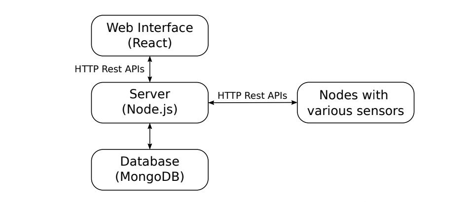
Express.js, a minimal and flexible Node.js web application framework, was also used in the back-end development of the full-stack. Using Express.js allows for URL routing and handling requests/responses, making it perfect for accessing and updating data in the MongoDB database (on obtaining requests from React.js).
The main objective of REST APIs is to enable a client to get desired data by pointing to a specific URL, with the URL acting as the request and the data obtained being the response.
- Application Programming Interface (API) -> a set of rules that allow clients and servers to talk to each other
- Representational State Transfer (REST) -> a set of rules for developing APIs
APIs have been written so that a node is capable of the following functions:
- Registering itself with the central server
- Going offline
- Updating its latest location, battery level and sensor data
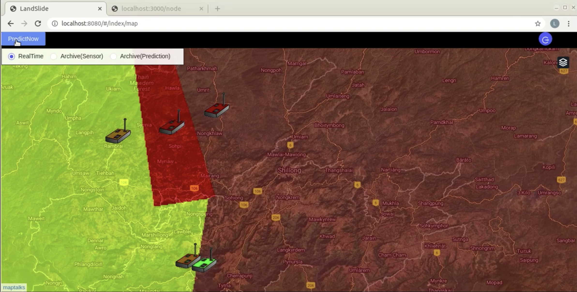
The front-end part of the full-stack is what a client (end user) sees when attempting to interact with the tool. On logging into the front-end, a map of the region under consideration is displayed with a ‘predict now’ button. A colour overlay would then be displayed on top of the map to indicate the probability of a landslide. Each prediction is stored in the database, making it possible to view prior predictions. The chance of slope-failure as indicated by the various colours are as follows:
- Yellow -> Moderate
- Red -> High
- Brown -> Very high
FUTURE PLANS:
In the coming months, the team plans to shift their focus to the hardware aspect of the project. One of the main tasks at hand involves combining multiple sensing modules (such as rain sensors, pore water pressure sensors, tilt sensors and GPS modules) along with a solar panel and a rechargeable battery onto a single Arduino-based microcontroller board. The plan is to then integrate Zigbee with this controller board, forming a 2-hop wireless network (2-hop refers to the fact that information is passed from the node to the central server via two intermediate points). Doing so will help establish a means of communication between the nodes on site, and the central servers (using the APIs developed so far). A few final touches to the front-end user interface are also underway with the main goals of improving the analytics and visualization of sensor data.
To minimize the cost of hardware used, the team aims to keep the total number of sensors used by the network as small as possible. Hence, another short-term goal of the team is to see if a model can be developed in order to optimize both hardware expenses and the accuracy of predictions. Ideally, such a model would take the topography (of the region we would want to monitor), node density and other related information as inputs, and identify the minimum number of sensors required at each node.